


وصف لـ My Elevation
My Elevation uses web services to get your precise surface elevation based on your current location. This is far more accurate than the elevation data provided by your device. But there's so much more you can do with My Elevation. Try it and see!
Notes:
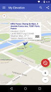
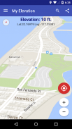
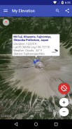
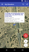
● The application shows the surface elevation above sea level based a latitude and longitude. It does not provide altitude in cases where you are in an aircraft, high up in a building, or high off of ground for some reason.
● This application must have a working data connection to be able to show your position on the map, get your precise elevation and provide much additional rich content . It does not have an off line mode. Please consider this before giving poor ratings when it doesn't work when you have no data connection.
Feature List
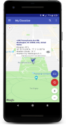
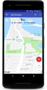
● Follow Me Mode - Follows your current location in real time. Watch your movements on a map and see your elevation and coordinates updating as you move.
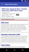
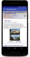
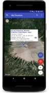
● Search for Locations and watch the map fly over to them. My Elevation will tell you the weather there and let you browse Wikipedia articles about attractions nearby the location. If you are curious at all about other places you will love this !
● Long press a location on the map and My Elevation will tell you the weather there and let you browse Wikipedia articles about attractions nearby the location.
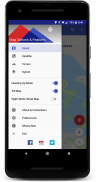
● Add bookmarks for places you want to remember.
● Share your location or what you find in searches with your friends in a text or email.
Display Options
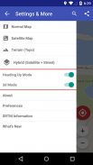
Map Mode - Lets you pick one of four Google Map types (Normal, Satellite, Topo and Hybrid)
Heading Up, Map Tilt and Night Mode
Try it out and let us know how it goes.
email us at rdhsoftware@gmail.com
or visit https://www.facebook.com/MyElevation
This application uses Google Analytics to collect anonymous data about how the application is used and what failures occur. This allows us to make the application better with each release. You can opt out of this by un-checking the Analytics data item in the application preferences. No personally identifying information is collected.
يستخدم My Elevation خدمات الويب للحصول على ارتفاع سطح دقيق استنادًا إلى موقعك الحالي. هذا أكثر دقة بكثير من بيانات الارتفاع التي يوفرها جهازك. ولكن هناك الكثير الذي يمكنك القيام به باستخدام My Elevation. جربها وانظر!
ملاحظات:
● يعرض التطبيق السطح الارتفاع فوق مستوى سطح البحر استنادًا إلى خطوط الطول والعرض. لا يوفر الارتفاع في الحالات التي تكون فيها على متن طائرة أو مرتفعة في مبنى أو مرتفعة عن الأرض لسبب ما.
● يجب أن يكون لهذا التطبيق اتصال بيانات فعال حتى يتمكن من إظهار موقعك على الخريطة والحصول على الارتفاع الدقيق وتوفير محتوى غني إضافي. ليس لديه وضع خارج الخط. يرجى مراعاة ذلك قبل إعطاء تقييمات رديئة عندما لا تعمل عندما لا يكون لديك اتصال بيانات.
قائمة الميزات
● اتبعني الوضع - يتبع موقعك الحالي في الوقت الحقيقي. شاهد تحركاتك على الخريطة وشاهد ارتفاعك وينسق عملية التحديث أثناء تنقلك.
● ابحث عن المواقع وشاهد الخريطة تطير عليها. سوف يخبرك My Elevation بالطقس هناك وسيتيح لك تصفح مقالات ويكيبيديا عن مناطق الجذب القريبة من الموقع. إذا كنت فضوليًا على الإطلاق بشأن الأماكن الأخرى ، فستحب هذا!
● اضغط لفترة طويلة على موقع على الخريطة وسيخبرك My Elevation بالطقس هناك وسيتيح لك تصفح مقالات ويكيبيديا عن مناطق الجذب القريبة من الموقع.
● أضف إشارات مرجعية للأماكن التي تريد تذكرها.
● شارك موقعك أو ما تجده في عمليات البحث مع أصدقائك في رسالة نصية أو بريد إلكتروني.
خيارات العرض
وضع الخريطة - يتيح لك اختيار أحد أنواع خرائط Google الأربعة (عادي ، قمر صناعي ، توبو وهاجين)
يتجه للأمام ، خريطة الميل والوضع الليلي
جربه واسمحوا لنا أن نعرف كيف ستسير الامور.
مراسلتنا عبر البريد الإلكتروني في rdhsoftware@gmail.com
أو تفضل بزيارة https://www.facebook.com/MyElevation
يستخدم هذا التطبيق Google Analytics لجمع بيانات مجهولة حول كيفية استخدام التطبيق وما هي حالات الفشل التي تحدث. هذا يتيح لنا تحسين التطبيق مع كل إصدار. يمكنك إلغاء الاشتراك عن طريق إلغاء تحديد عنصر بيانات Analytics في تفضيلات التطبيق. لا يتم جمع معلومات التعريف الشخصية.
My Elevation - إصدار 1.74
(04-01-2024)My Elevation - معلومات APK
نُسخة APK: 1.74الحزمة: com.rdh.mulligan.myelevationتطبيقات من الفئة نفسها
قد يعجبك أيضًا...


